Abia State was created out of the old Imo State in 1991 under the then military administration. The State is located in the South East region of Nigeria and comprises of 17 local government areas. It occupies about 6,320 kilometers and is bordered by the states of Enugu and Ebonyi to the north, Akwa Ibom to the east and southeast, Rivers to the south and southwest, and Imo and Anambra to the west.[1] The State has a population of about 2.4 million people.[2]
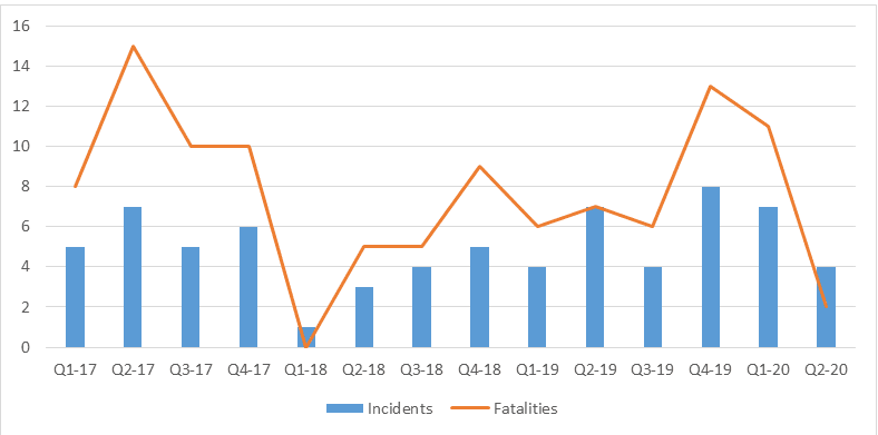
Conflict issues in Abia State include communal tensions, violent criminality, land disputes, armed robbery, kidnapping, human trafficking, and ethno nationalist agitations. According to data, Abia State has repeatedly recorded low conflict incidents and fatalities compared to other States in the Niger Delta from 2016-2019[3].
Communal tensions, ethnic nationalist sentiments, and land disputes continue to be a persistent feature of the conflict landscape in Abia State. According to a report by the Foundation for Partnership Initiatives in the Niger Delta (PIND), there was an increase in reported incidents of conflict risk and violence in Abia state in from April to June 2020, compared to January to March 2020. Abia was among the least violent States in the Niger Delta during the period, based on reported fatalities. Ikwuano and Aba North LGAs had the highest levels of lethal violence in the state during the quarter. Conflict risk and violence during the period were mainly driven by criminality, communal conflict, and extra-judicial killings by security operatives[4].
 Loading...


